Indian Geography

1. भारत में सर्वाधिक विनाश वाले भूकंप किस क्षेत्र में आते है ?
(अ) हिमालय
(ब) अरावली
(स) नीलगिरी
(द) सतपुड़ा (अ)
1. In which area do the most devastating
earthquakes occur in India?
(a) Himalayas
(b) Aravali
(c) Eucalyptus
(d) Satpura (A)
2. भूकंपीय अन्तराल कौनसा क्षेत्र होता है ?
(अ) पिछले दस वर्षों में कोई भूकंप न आया हो
(ब) पिछले बीस वर्षों में कोई भूकंप न आया हो
(स) पिछले पचास वर्षों में कोई भूकंप न आया हो
(द) पिछले सौ वर्षों में कोई भूकंप न आया हो (द)
2. What is the seismic interval?
(a) There has been no earthquake in
the last ten years
(b) There has been no earthquake in
the last twenty years
(c) There has been no earthquake in
the last fifty years
(d) There has been no earthquake in
the last hundred years (D)
3. कांगड़ा व बिहार में भूकंपों के बीच का भाग कितने किलोमीटर लम्बा है, यहाँ निकट भविष्य में कितने भूकंप आने की सम्भावना है ?
(अ) 1300 किलोमीटर लम्बा और 7 भूकंप आने की सम्भावना
(ब) 1100 किलोमीटर लम्बा और 5 भूकंप आने की सम्भावना
(स) 900 किलोमीटर लम्बा और 4 भूकंप आने की सम्भावना
(द) 700 किलोमीटर लम्बा और 2 भूकंप आने की सम्भावना (द)
3. How many kilometres is the area
between the earthquakes in Kangra and Bihar, how many earthquakes are likely to
occur here in the near future?
(a) 1300 km long and 7 earthquakes likely
(b) 1100 km long and 5 earthquakes likely
(c) 900 km long and 4 earthquakes likely
(d) 700 km long and 2 earthquakes likely to occur
(D)
4. भूकम्प शांति की अवधि लगभग कितने वर्ष होती है ?
(अ) 20 वर्षों की
(ब) 25 वर्षों की
(स) 30 वर्षों की
(द) 35 वर्षों की
(स)
4. How many years is the period of
earthquake peace?
(a) 20 years
(b) 25 years
(c) 30 years
(d) 35 years old (C)
5. शरावती नदी पर स्थित गरसोपा प्रपात किन राज्यों की सीमा पर है, जो भारत का सबसे ऊँचा जल प्रपात है ?
(अ) महाराष्ट्र व कर्नाटक
(ब) कर्नाटका व तमिलनाडु
(स) महाराष्ट्र व मध्यप्रदेश
(द) कर्नाटक व तेलंगाना
(अ)

5. On the border of which states is the
Garsopa Falls situated on the Sharavati River, which is the highest waterfall
in India?
(a) Maharashtra and Karnataka
(b) Karnataka and Tamil Nadu
(c) Maharashtra and Madhya Pradesh
(d) Karnataka and Telangana (A)
6. बेरन द्वीप पर ज्वालामुखी उद्गार कब हुआ ?
(अ) 1790 में
(ब) 1803 में
(स) 1810 में
(द) 1815 में (ब)

6. When did the volcano erupt on the
island of Barren ?
(a) in 1790
(b) in 1803
(c) in 1810
(d) in 1815 (B)
7. चुलिया जल प्रपात किस नदी पर स्थित है ?
(अ) चम्बल नदी
(ब) नर्मदा नदी
(स) गोदावरी नदी
(द) बनास नदी (अ)
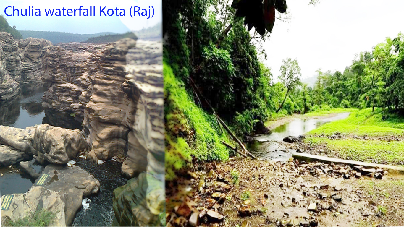
7. On which river is the Chulia Falls
situated?
(a) Chambal River
(b) Narmada river
(c) Godavari river
(d) Banas River (A)
8. भारत को कितने भौतिक भागो में बाटा गया है ?
(अ) 5
(ब) 4
(स) 3
(द) 2 (ब)
नोट- भारत सरकार के राजपत्र 1964 के अनुसार एस.पी चटर्जी ने भारत के भौतिक भागों को चार भागों में बाँटा गया है।
8. Into how many physical parts is India
divided?
(a) 5
(b) 4
(c) 3
(d) 2 (B)
9. शिवालिक हिमालय की औसत ऊंचाई कितनी है ?
(अ) 200 से 1000 मी.
(ब) 300 से 1100 मी.
(स) 400 से 1200 मी.
(द) 600 से 1500 मी. (द)

9. What is the average height of
Shivalik Himalaya?
(a) 200 to 1000 m.
(b) 300 to 1100 m.
(c) 400 to 1200 m.
(d) 600 to 1500
m. (D)
10. लघु हिमालय की ऊंचाई कितनी है
?
(अ) 500 से 2000 मी.
(ब) 700 से 2500 मी.
(स) 900 से 3000 मी.
(द) 1000 से 4500 मी.
(द)
10.
What is the height of
the Lesser Himalayas?
(a) 500 to 2000 m.
(b) 700 to 2500 m.
(c) 900 to 3000 m.
(d) 1000 to 4500
m. (D)
11. दार्जिलिंग,चकराता,मसूरी,अल्मोड़ा,रानीखेत,नैनीताल किस हिमालय पर स्थित है?
(अ) लघु हिमालय
(ब) महान हिमालय
(स) मध्य हिमालय
(द) ट्रांस हिमालय
(अ)
11.
Darjeeling, Chakrata,
Mussoorie, Almora, Ranikhet, Nainital are located on which Himalayas?
(a) Lesser Himalayas
(b) Great Himalayas
(c) Middle Himalayas
(d) Trans Himalaya (A)
12. वृहद हिमालय की औसत ऊंचाई कितने मीटर है
?
(अ) 5000 मी.
(ब) 6000 मी.
(स) 7000 मी.
(द) 8000 मी. (ब)
12.
How many meters is the
average height of the Greater Himalayas?
(a) 5000 m
(b) 6000 m.
(c) 7000 m
(d) 8000 m (B)
13. कश्मीर घाटी की प्रमुख नदी कौनसी है ?
(अ) झेलम नदी
(ब) चिनाव नदी
(स) सतलुज नदी
(द) सिन्धु नदी
(अ)

13.
Which is the main river
of Kashmir Valley?
(a) Jhelum River
(b) Chenab river
(c) Sutlej River
(d) Indus river (A)
14. जोजिला दर्रा वर्तमान
में कहाँ स्थित है ?
(अ) सिक्किम
(ब) हिमाचल
(स) लद्दाख
(द) जम्मू कश्मीर (स)

14.
Where is Zojila Pass
located?
(a) Sikkim
(b) Himachal
(c) Ladakh
(d) Jammu and Kashmir (C)
15. नाथुला व जेलेपला दर्रा कहाँ स्थित है
?
(अ) जम्मू कश्मीर
(ब) लद्दाख
(स) सिक्किम
(द) हिमाचल (स)
15.
Where are the Nathula
and Jelepla passes located?
(a) Jammu and Kashmir
(b) Ladakh
(c) Sikkim
(d) Himachal (C)
16. काराकोरम को संस्कृत में क्या कहते है ?
(अ) कृष्णागिरी
(ब) अंजनगिरी
(स) अरावली
(द) शात्रवः (अ)
16.
What is Karakoram called
in Sanskrit?
(a) Krishnagiri
(b) Anjanagiri
(c) Aravali
(d) Shatrava: (A)
17. हिमालय का प्रादेशिक वर्गीकरण सिडनी बुरार्ड ने कितने भागो में किया
है ?
(अ) 3
(ब) 4
(स) 5
(द) 6 (ब)
17.
In how many parts has
Sydney Burrard made the regional classification of Himalayas?
(a) 3
(b) 4
(c) 5
(d) 6 (B)
18. असम में अधिकांश पहाडियों का नामकरण किनके के नाम पर किया गया है ?
(अ) जनजातियों के नाम पर
(ब) नदियों के नाम पर
(स) भाषा के नाम पर
(द) गांवों के नाम पर
(अ)
18.
After whom are most of
the hills in Assam named?
(a) in the name of tribes
(b) in the name of rivers
(c) in the name of language
(d) the name of the village (A)
19. हिमालय की उत्पत्ति कितने मिलियन वर्ष पुरानी मानी गयी है ?
(अ) 40 से 50 मिलियन वर्ष
(ब) 50 से 60 मिलियन वर्ष
(स) 60 से 70 मिलियन वर्ष
(द) 70 से 80 मिलियन वर्ष (स)
19.
How many million years
old is believed to be the origin of the Himalayas?
(a) 40 to 50 million years
(b) 50 to 60 million years
(c) 60 to 70 million years
(d) 70 to 80 million years (C)
20. हिमालय पर्वत श्रेणी निम्नलिखित में से किस राज्य का हिस्सा नहीं है
?
(अ) उत्तराखंड
(ब) हिमाचल प्रदेश
(स) सिक्किम
(द) उत्तर प्रदेश (द)
20.
The Himalayan mountain
range is not a part of which of the following states?
(a) Uttarakhand
(b) Himachal Pradesh
(c) Sikkim
(d) Uttar Pradesh (D)